
Digital Surveillance Technology Drone Thermal Camera Dashboard
A digital surveillance technology drone thermal camera dashboard displays live heat signatures and flight data to help operators identify targets in low-light conditions. It converts infrared energy into a visual feed, allowing users to monitor temperature differences across a landscape through a unified interface during search or inspection missions.
Digital drone surveillance hardware
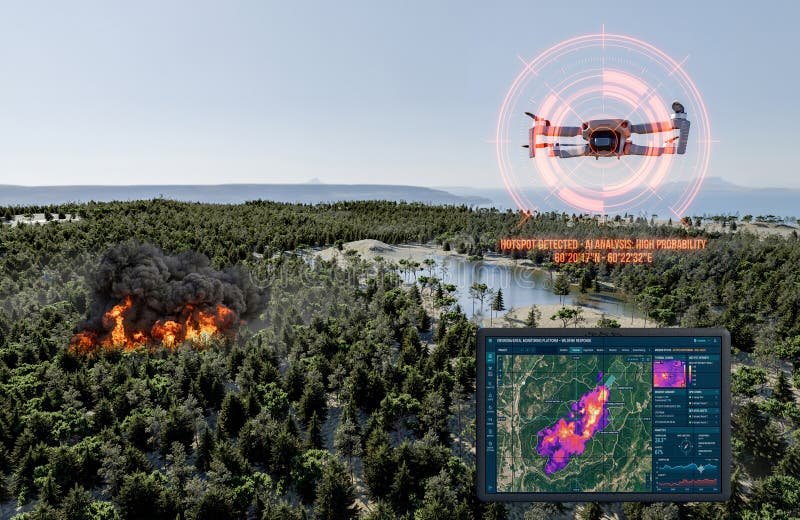
A monitoring setup relies on specific hardware and software to translate raw infrared data into actionable intelligence. The performance of these tools depends on the sensor resolution and the processor speed, which you can verify by checking the technical specifications provided by the manufacturer in the user manual.
| Part or input | What it does | What you notice when it goes wrong |
|---|---|---|
| Thermal Sensor | Detects infrared energy levels | Image appears blurry or pixelated |
| Video Link | Sends data to screen | Signal drops or screen freezes |
| Display Monitor | Shows the heat feed | Colors look washed or dim |
| Control Software | Processes the thermal data | Interface lags or crashes often |
| Battery Pack | Powers the camera unit | System shuts down without warning |
Operating the Imaging Interface
Executing a flight mission requires a sequence of checks to ensure the thermal feed remains stable and accurate throughout the operation. Each step involves verifying the connection between the airborne unit and the ground interface to prevent data loss.
- Power on the drone and the ground controller to initiate the handshake between the two devices.
- Check the signal strength on the dashboard to ensure the link remains stable at your current range.
- Adjust the gain and level settings to highlight the heat signatures you need to monitor for the mission.
- Monitor the battery levels on the display to ensure at least twenty percent capacity remains for a safe return.
- Record the feed directly to the onboard storage card if you need to review the footage later tonight.
- Land the aircraft manually if the thermal feed becomes jittery or the signal latency exceeds two full seconds.
Why Technical Errors Impact Results
Tracking issues often stem from a disconnect between the sensor’s calibration and the surrounding environment’s ambient temperature. When the camera can’t distinguish between a target and the background, it’s usually because the gain settings are too low for the current contrast levels. According to the Federal Aviation Administration’s drone safety guidance, operators must maintain a clear line of sight to ensure the technology functions within legal and safety parameters.
Configuration Limits and Adjustments
What you control
- Gain and level settings to increase contrast.
- Calibration intervals to refresh the sensor baseline.
- Signal frequency channels to reduce interference.
- Display brightness to suit the local lighting.
What is fixed by design
- Sensor resolution, which determines image clarity.
- Maximum refresh rate of the thermal feed.
- Physical range of the wireless transmission link.
If you need to perform professional-grade thermal analysis, you may require specialized certification for data interpretation. Attempting to modify the internal circuitry or software firmware often voids the manufacturer warranty and can lead to permanent hardware damage. Always consult the official support portal before performing any advanced system updates.
Improving Thermal Data Accuracy
To get better results, you must consider how the time of day affects thermal readings. Objects lose heat differently as the sun sets, Always keep the lens clean, as a thin layer of dust or moisture can distort heat signatures and lower your detection range. If you’re tracking small targets, fly at a lower altitude to keep the pixel density high.
How do I fix a frozen thermal image?
A frozen image usually indicates a signal loss, so you should attempt to re-establish the connection by moving the controller closer to the drone. If it remains frozen, restart the display software immediately.
Is it safe to fly in the rain?
No, most thermal drones aren’t waterproof and moisture will cause short circuits in the sensor housing. You should land the drone immediately if precipitation begins during your flight mission.
How long does the battery last?
Battery life typically ranges from twenty to forty minutes depending on the model and the flight conditions. You should check the manufacturer label for the exact capacity rating in milliamp hours.
Can I see through walls with these cameras?
No, thermal cameras detect surface heat signatures and can’t see through solid objects like concrete or steel. They only show the temperature of the surface facing the lens at that moment.
What happens if the signal drops?
The drone will likely trigger an automatic return-to-home sequence to ensure it doesn’t crash. You must ensure your return altitude is set high enough to clear local obstacles beforehand.
Does wind speed affect thermal accuracy?
Yes, high wind speeds cool down surfaces and reduce the contrast needed for the thermal sensor to function. You should fly in winds below fifteen miles per hour for the best results.
Digital surveillance, in short
As these tools become more accessible, you’ll find them increasingly helpful for keeping your team safe during nighttime operations. You shouldn’t wait to start practicing with this equipment in controlled environments. Once you’re comfortable with the interface, you’ll be ready to handle real-world challenges with much greater confidence and precision.
